Sunday, April 8, 2012

Beaufort, S.C.

IMG_3439

This is a beautiful little town! We woke to sunny, warm (not hot), perfect conditions and motored ashore in the dinghy, having anchored out adjacent to the marina last night. Being Easter morning, nothing was open yet except for a few restaurants, so we walked the streets and shoreline for a couple hours, at the end of which Bob said “I could imagine living in this place”, a stunning statement coming from Bob, as those of you who know him will understand.

2012-04-091

At noon we boarded a horse-drawn carriage for a 1-hour tour with a guide telling us the history. Unlike in Savannah where the guide spoke only of the Revolutionary War, here the guide included lots of Civil War history as well, of the social/cultural type, not the battles. We found it most interesting.

2012-04-09

We arrived at Blackstone’s cafĂ© for late brunch and ordered  Crabcake Benedict:  that’s right, 2 crabcakes, each topped by a poached egg and Hollandaise sauce! Crawford and Mackenzie, we thought of you two as we know how you love eggs benedict. It was as good as your imagination conjures.

IMG_3438

More wandering the streets, and by late afternoon we dinghied back to the boat, having pretty much seen all of this pretty, small (pop. 13,000) town.

Saturday, April 7, 2012

South Carolina: Our Third State

Days on Cruise: 15

Today’s distance:  47.9 statute miles

Time Traveled:  6 hrs

Total trip odometer:  449 miles

IMG_3390

We woke up to cool temps, around 50, but sunny weather, so after checking the NOAA weather forecast and Windfinder.com, we decided to head north.  Proceeding from Thunderbolt on our way to cross the Savannah River, we passed the Bonaventure Cemetery, made famous in the book “Midnight in the Garden of the Good and Evil”, mentioned in a previous post.

IMG_3396

P1000406

Where the ICW channel intersects with the Savannah River we met an incoming RoRo (roll on, roll off ship) coming in from the sea.  Since she was the “stand on” vessel, we yielded right of way to her. As if we had a choice!

IMG_3407

After crossing the Calibogue (pronounced Cal-eh-bo-gee)   Sound, we cruised past Hilton Head Island. Everything we’ve heard about HH says it’s a great stopover. Unfortunately they’re preparing for a major golf event next week after the Augusta Masters golf tournament ends, and we’re told moorage is running $8/foot/night, up from their usual rate of $2.00.  Let’s see:  8 X 42 = too much for tying up to a dock to sleep on our own boat! We’re sure we’re missing a beautiful beach (we saw it from our boat) and lovely (very expensive) restaurants, but we’ll see plenty of each on our 6,000+ mile journey.

IMG_3406

IMG_3416

As with the ICW in much of Florida and parts of Georgia, South Carolina has its share of “nice” houses.  The style here, as in Georgia, is much more “elegant Southern”, compared to the glitz of Florida.

IMG_3414

Near the end of our day we passed Parris Island where many of our nation’s Marines take their basic training.  We’ve read that there are squadrons of F 18 Hornets based nearby and we’re likely to experience flyovers while in Beaufort.

IMG_3420

We arrived in Beaufort mid-afternoon, then dropped the anchor in 20 feet of water on a rising tide with about 3 knots of current.  We decided to have a relaxing afternoon on the boat, which would allow us to evaluate the set of our anchor in this changing tide and reversing current.  If all goes well, which we expect it will, we’ll then feel comfortable leaving the boat for the day tomorrow while we explore what is supposed to be a charming southern town.

Friday, April 6, 2012

Moving On, Eventually

We planned to move on north today after our stay in Savannah,  but one of those boating variables changed our plans:  Weather!

IMG_3387

The table below comes from a website called Windfinder and provides both current conditions and predictions throughout the world, although they get a bit more scattered once away from the eastern US.

photo (5)

The table shows the predicted wind in Beaufort, South Carolina, about 50 miles north of us and our intended next  destination.  While the forecast is for the near-shore ocean, not specifically the ICW, we have to cross two large, exposed Sounds directly connected to the ocean between here and there.  The cruising guides say they can get very rough in high winds, and we think 33 knots qualifies.

photo (6)

So, here we stay for another day or so until the conditions improve.  Interestingly, the winds in Charleston, SC just 50 miles north of Beaufort are benign.  Beam us up, Scottie!

Thursday, April 5, 2012

Re-connecting

P1000400

Cathryn met Laura at age 12, in Music class at school in Houston. They became best friends and spent the next 6 years helping each other through the agonies of adolescence: zits, boys, parents, homework, attending Girl Scout Camp together on the Gulf of Mexico where they learned to sail, double dates, and finally figuring out where to go to college.  They saw each other regularly during college years, and periodically thereafter, including their high school 10 and 20-year reunions. Their last visit was 10 years ago.

P1000404

Cathryn recently learned that Laura had moved to Atlanta,  so called her from Cumberland Island, GA last weekend to see if there was a chance they could see each other while in the same state. It turns out Atlanta is a 5-hour drive to the coast where we are, BUT coincidentally Laura and her family planned to drive through Savannah on their way to an Easter-weekend getaway at Jekyll Island, only one hour from where we are in Savannah!

P1000401

Today Laura, her husband Tom, and their beautiful daughters Stephanie and Emily arrived at the boat about 3:30 and visited for 5 hours of non-stop talk and dinner! It’s not possible to “catch up” in 5 hours after a 10-year gap, but we sure tried hard and made good progress! It was terrific to see them all again, and Bob was meeting them for the first time.  What fun, and we promised to never again let more than 5 years pass between visits. Cathryn casts a hearty vote in favor of reconnecting any chance you get!

P1000405

Wednesday, April 4, 2012

Savannah, GA

IMG_3356

We woke up this morning to Thunderbolt Marina's signature benefit, delivered directly to the boat daily: a box of 6 still-warm Krispy Kreme doughnuts and the newspaper.  They had fresh brewed coffee up at the office as well, but we chose to stick with our boat-brewed Martin Henry Coffee from home.  We did manage to limit our intake to 4 of the donuts, but 6 more will show up again tomorrow morning. We asked if we could get just 2 and were told the choices were 6 or 12 !!!  We’ll have to increase our exercise or leave here, or else we’ll become diabetic in a mere matter of days.

IMG_3357

Savannah is most noteworthy for it’s beautiful Victorian, Italianate and Colonial-style homes, as well as the spectacular 24 Squares that are laden with oak and magnolia trees, moss, statues and monuments, each one a park-like setting with benches and walking paths. 

One of the lovely homes is that in which Juliette Gordon Low, founder of the Girl Scouts, was born and raised. Because Cathryn was a Girl Scout for many years and credits her early great love of the outdoors to this experience, she enjoyed seeing Juliette’s home and church.  This year is the 100-year-anniversary of Juliette’s founding of the Girl Scouts, and celebratory events are planned in Savannah.

IMG_3363

We took the public transit bus into town, our second experience with public transit while on this trip.  Unlike the Key West bus back to Marathon, everyone on this bus was sober and well behaved.  We were the only white people on the bus except for the driver (all others were black) and we were told by him that “white people don’t ride the bus in Savannah”.  Hmmm . . . not like Seattle.

IMG_3361

For those of you have read John Berendt’s non-fiction bestseller “Midnight in the Garden of Good and Evil” set in Savannah, as Cathryn has, today’s tour strongly summoned that feel of the book and city.  She’s still amazed this true crime story happened in a southern city as depicted in the book, which evokes a heavy Southern-Gothic feel, is astonishing and hilarious at the same time, with remarkably eccentric characters. It’s true history from the 1980s and includes a murder, 4 trials before the judge finally moved the venue out of Savannah, and a fascinating story.

IMG_3366

Savannah was established in 1733, but a fire in the 1790s destroyed much of the city.  Now large parts of the expansive historic district of this city of 140,000 people is composed of buildings from the early to late 1800s.  It’s a great place to walk the streets and absorb the various architectural styles.

IMG_3379

Down by the river was a roadway made of ballast stones off of ships from the early years.  In the mid 1800s farmers drove their wagons full of cotton bails under these walkways where cotton buyers stood above, evaluated the quality of the cotton, and placed bids on the cotton.

IMG_3385

At the end of the day after lots of walking in the high heat, we settled down for a beer in an outdoor cafĂ© while waiting for a return bus, as it runs only infrequently to our marina.  Our timing was perfect!  Right after we sat down an afternoon thunderstorm hit and dropped a huge amount of rain in just a few short minutes.  We finished our beer, the rain stopped, and we walked to the bus. Timing is everything!

Tuesday, April 3, 2012

On to Savannah!

Days on Cruise:  11
Today's distance: 25.1 statute miles
Time traveled:  3 hrs 40 mins
Total trip odometer:  401 miles

IMG_3341
Tuesday morning we traveled the last 30 miles to Savannah.
IMG_3343
A few miles before our arrival, the marshlands scenery changed to lots of trees, houses began to appear and we left the wild lands behind.
IMG_3331
IMG_3333
We're at Thunderbolt Marina a few miles away from downtown as we're told the downtown marina has very strong currents and the container ships going in and out all night will keep the boat rocking and rolling, preventing good sleep.
images
There are two more Looper boats here, both parked directly in front of us.  Jerry and Janet from Kansas City began their Loop last Fall at Kentucky Lake on the Tennessee-Tombigbee Waterway. They invited us to join them for dinner at  "Tubby's" a half mile walk away, and we enjoyed talking Looper stuff and had a beer on their sundeck afterwards, including a tour of their 42' Carver. Nice folks, and we expect we'll run into them again as we both continue north.
IMG_3347

Monday, April 2, 2012

Goodnight, Sleep Tight

2012-04-02

Middle of Nowhere

Cumberland Isle to Buckhead Creek off Ossabaw Island, GA

Days on Cruise: 10

Statute Miles Today:  69

Travel Time:  7 hours 52 minutes

Total Odometer:  376 miles

IMG_3276-001

We started the day with no particular destination in mind, thinking we would go until we felt we were done for the day.  This stretch of the Georgia ICW is as remote at it gets.  A sea of grass.  So we ended up continuing until 4:30, thus making it our longest cruising day to date. But we had a great day  seeing the sights.

IMG_3277-001

All day we traveled a serpentine route through marsh and grasslands, with trees 5-10 miles in the distance, broken occasionally by a large Sound to cross with an inlet from the ocean.  We saw almost no other boats, only a handful of cottages, and no towns or cities.

IMG_3297

The exception to the “almost no other boats” was a small, 100-passenger cruise ship “Independence” who wound her way up the ICW ahead of us for much of the afternoon.
IMG_3286

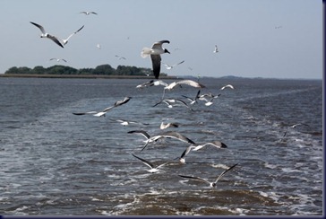
We did, however, see lots of pelicans, dolphins and seagulls. In fact, at one point it felt almost like Hitchcock’s movie The Birds as we were followed closely by 50-100 seagulls for many, many miles, just off our stern and occasionally beside and in front of us, cawing loudly and continuously.

IMG_3304

The most “interesting” part of the day was when we traveled the aptly named Little Mud River. The cruising guides suggest traveling it at high tide because it’s badly shoaled and becomes very shallow. Tides move about 9 feet from high to low here. Our timing was off, and after studying the nautical charts closely, and knowing we have only a 3’ 7” draft (how deep our boat goes below the water) we decided to go for it even though it would put us there only an hour after low tide. As the depth gauge continued to drop from 10 to 7 to 4 feet beneath our hull, we throttled back to idle speed and proceeded cautiously, agreeing that if the water got “too skinny”, we’d drop the anchor and wait for the water to come up. Finally, at 1.9 feet under the hull, we were just about to decide we didn’t want to proceed further when it began moving slowly to greater depths.  Whew! Big sigh of relief.  Boaters with greater draft than ours will definitely want to do this 5-mile stretch at something other then low tide!  “Independence” was not on this segment; they must have gone ‘outside” to the Atlantic.

IMG_3301

(Still in search of the “great” dolphin photo!)

We were also kept company today by numerous black flies, though the wind was strong enough to mostly keep them from being a nuisance.  We’re glad to have screens on our ports, hatches and doors, and will close things up, run the generator and turn on the air conditioning if necessary. It’s 85 degrees today, so plenty warm.

IMG_3294

We’ve gotten really good at trading off helm duty, finding other things to do when we’re not the person at the helm, and working on navigation together any time things get a bit confusing.

IMG_3284-001

Unlike in Florida where we successfully set the anchor the first time every time, we again had trouble the first time tonight and had to re-set a second time. Something about this Georgia mud bottom???

Sunday, April 1, 2012

Cumberland Island to St. Simon’s Island, GA

Days on Cruise: 9

Today’s Trip:  29.2 miles

Travel Time: 3 hrs. 40 mins

Total Odometer:  306 statute miles

After finishing our Cumberland Island exploration, we didn’t want to sit on the boat for  hours until bedtime, so pulled the anchor and took off, contrary to “Plan”. Thank goodness our friend Hobie has taught us to “cast all plans in jello” so we can go with the flow!

IMG_3272

We continued north, crossing Andrew’s Sound which was interesting. It’s a large body of water that’s so shoaled over by sand coming in the ocean inlet that it’s too shallow to transit, so the ICW markers take you all the way to the breakers in the Atlantic before sending you back inland. We were fortunate to have a beautiful, calm day for this crossing made at high tide, so there were no issues.

IMG_3268

In addition to the usual dolphins and pelicans, today we saw a Spotted Eagle Ray, about 4 – 5 feet across in size, leap from the water and do a “barrel roll” about 100 feet in front of the boat, reminiscent of the many times we saw whole schools of stingrays do the barrel roll during our previous 3 winters in Baja, Mexico.  Sorry, no pictures, as it happened too fast.

IMG_3265

IMG_3250

We saw thousands of jellyfish in the water, where earlier in the day we had seen them on the beach. We were glad we were not swimming!

IMG_3270

We continued north along Jekyll Island where we saw some of the early 2oth century splendor of the beach houses in which some of the nation’s top 0.0o1% struggled through the winters.

Next we crossed St. Simon’s Sound, another large body of water, though the water was deeper here. We left the ICW to anchor near Morningstar Golden Isle Marina for the night and had some trouble anchoring. We tried twice, and neither time would the anchor “set”, so we moved down the shore a couple hundred yards and tried again – success!

Cumberland Island, Take II

We got up this morning to sunny blue skies, so got going early and loaded both bikes into the dinghy to go ashore. This was the first time we’ve left the boat alone AT ANCHOR, and Cathryn was anxious about it the in days leading up to knowing we would do this, but by the time we took off, the boat had been there almost 24 hours, the anchor was clearly secure, so she was no longer worried about the anchor slipping and returning to find the boat gone or grounded ashore – another milestone event!

P1000368

We headed south on the island, riding five miles down the one-lane, tree-shaded road made of packed sand and crushed shells. It was level terrain, so an easy ride with spectacular forest of pine, oak, palm and other under-story we can’t identify as we aren’t familiar with the trees and shrubs here.

P1000382

IMG_3257

Along the way we passed one of the few private homes remaining on the island.  It was quite a nice “winter cabin” with a grass airstrip across the road to make access just a little easier than either private boat or use of the public ferry, the only way to get to Cumberland Island as there’s no road access.

IMG_3250

After traveling 5 miles on the road, we set off on a side-road to the east side of the island on the Atlantic Ocean, crossing dunes and passing a campground where people can get permits to backpack in and camp. We walked the beach where we saw no one other than a mother and her child.

2012-04-011

On arrival back at Plum Orchard we returned to the mansion and and sat on the porch to eat our picnic lunch, before walking to some nearby ponds looking for alligators, reportedly residents here, though we saw none.

P1000386

Not finding any alligators. we decided to walk around to the other side of the mansion to get a better understanding of the size of the mansion.  What we described yesterday as “not very architecturally interesting” surprised us!

2012-04-01

This "simple house" consisted of 21,724 square feet after the 1906 additions were made.  Those additions included wings on both the East and West ends.  The East wing houses a 12-foot deep swimming pool filled by artesian water and a squash court with viewing balcony.  The Park Service reports the basement has 6,022 square feet, the first floor 7,209, the second floor 5,493, and the attic 3,000 square feet.  Wow!