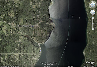
Saturday, January 31, 2009

San Ignacio Town

As planned, we drove into the lovely town of San Ignacio for dinner and ate at an outside table right on the square, at a restaurant where we’d stopped for a beer yesterday. The restaurant was adjacent to the church built 300 years ago. As the evening wore on, a large and very well-dressed crowd of Mexicans began congregating on the steps of the church, and we eventually learned the occasion was a Quinceanera, or celebration of a young girl’s turning 15 and being “presented” to family, friends and the community. The honored young girl was dressed in a full-length white dress with colorful ribbons, many layers of fabric and her hair done in a fancy style. She looked beautiful and nervous, but happy. We heard the music playing in the church as the event continued but did not venture inside to watch.

San Ignacio Lagoon

We drove 40 miles (90 minutes) to San Ignacio Lagoon this morning on a type 2 road, which many people had described to us as awful. We didn’t enjoy it surely, but maybe because of the descriptions we’d heard, we didn’t think it was so bad (better than your roads in Monteverde, Jim and Phebe). We did, however, decide we won’t take the Chalet on type 2 roads. We probably wouldn’t have felt comfortable going even half the speed we did today if we’d had the trailer and were glad we left it behind in the campground and made it a day trip. Once at the lagoon, we found the Ecoturismo Kuyima Camp (pictured) and after a briefing, went at high speed in our panga (small boat) with a guide and two Mexican tourists until we got to the part of the lagoon where observation of the whales is allowed. They were everywhere, whichever direction you looked. While not always, often we were within 20 feet of them. Only the adult females and baby whales hang out in the lagoon, and some of the females have not yet given birth, so they swim around in pairs until their time comes. The whales are in the range of 15-20 meters in length. At several points a single adult female came within 5-10 feet of the boat, looked at us, then swam directly under the boat, which was slightly adrenaline-producing as we could imagine what might happen if she decided to come up for air while beneath our small boat! The weather was sunny and warm, the water was clear, and the scenery was spectacular, with hills in the distance beyond the shoreline. Our guide spoke no English and Cathryn remains sensitive about her somewhat tortured Spanish, so we didn’t learn much about the whales, and the guide didn’t seem to have a teaching role in any case. We got back to our campground 3pm and plan to eat dinner at a restaurant on the square in town tonight. There are 4-5 other RVs in this campground, and we expect them to get progressively fuller as we continue south into the more populated tourist areas of La Paz and the Cabos.

Friday, January 30, 2009

The Gasoline Gap

All gas in Mexico is sold at government-owned PEMEX stations at a fixed price, currently about $2.40 a gallon. This is the same price it was sold for a year ago when gas in the U.S. was in the $3-4 a gallon range. The travel guide books warn that even though the maps say there are PEMEX stations in certain locations, some of them are abandoned and others sometimes run out of fuel for a day or two. As a result, they suggest you always fill up when you hit half a tank. El Rosario (remember Mama Espinosa’s where we ate lobster burritos?) to Guerrero Negro is a stretch of 240 miles known as “the gas gap” where there are no gas stations! It’s a mystery to us why in some places there are 3 stations (remember all government-owned, with the same price) within a quarter of a mile, and then they allow this “gap”, but they do. Now most cars can easily go 240 miles between fill-ups, but while we are hauling the Chalet, there have been a couple of times when the road conditions didn’t allow us to go much further, so this gap could have found us pulling into Guerrero Negro on fumes. As always, the entrepreneurial spirit prevails. In Cativina about 80 miles into “the gap”, there are a couple of guys beside the road selling gas out of a 55 gallon drum. They of course charge a premium, about $4.00 a gallon, but we happily agreed to pay for the peace of mind. It also allowed us to feel comfortable driving around the Catavina area the day we were there, exploring some side roads into the boulders.

San Ignacio, Baja Califonia Sur

N 27*17.907 W 112*54.907
We left Catavina this morning and drove 240 miles to San Ignacio in Baja California Sur. (There are two states on the Baja California Peninsula; the boundary between the two is the 28th parallel, where we also crossed a time zone and are now on Mountain Time). This distance took about 5 hours. We found a couple of inland stretches where frankly there wasn’t much interesting scenery and we felt powering through them was the best way to get to the places we prefer to be. We’re staying at a campground amusingly named “Rice and Beans”; it has power, water, free unlimited Wi-Fi we can get at our campsite, and much to Cathryn’s delight, free hot water showers in the nicest bathrooms we’ve seen since we left Olalla! Bathrooms continue to be an ongoing “issue” for her. We dropped the Chalet off at the campground around 2PM and went a mile into town to make arrangements for tomorrow’s gray whale-watching boat trip at the San Ignacio Lagoon. We spent a pleasant couple of hours wandering the town square and sitting in a sidewalk cafĂ© for a cerveza. The high temp today was 82, and we are currently sitting in the camper at 8:30 at night with the door open, while it’s 70 degrees and not windy. San Ignacio is the most beautiful town we’ve seen yet. It is a date palm oasis about 40 miles inland from the Bahia de la San Ignacio lagoon with a river running through it.

Thursday, January 29, 2009

Campground Neighbors

Yesterday afternoon in search of Baja intelligence from more experienced travelers, Cathryn approached the only other RV in our campground and met Jim and Jan Morris from Penticton, British Columbia, Canada (actually she’s originally Australian). While they’re seasoned RV travelers in Australia, Europe, Canada and the U.S. who spend 2-3 months every year in their RV, this is also their first trip to Baja. They own a business making bike rack (Swagman brand, a swagman is the Australian version of a hobo), so we got their contact information for the possibility that we’ll ultimately figure out how to bring our bicycles along on the Chalet. Nice folks, and we may run into them again in Loreto or other points further south. We’ll remember to get a picture of them next time. Another campground “neighbor”: Yesterday afternoon immediately upon our arrival at Rancho Santa Inez, a man on a 3-wheel ATV trailing a dog on a leash approached us. Turns out he and his wife live in New Mexico 6 months of the year, and just up the canyon road from our campground the other 6 months of the year, as they’ve been doing for 8 years. They live in off-grid homes he constructed himself in both places. He is a bit of a talker and has a colorful history (military, power companies, private pilot, search and rescue) and invited us to walk up the road to his home for a cup of coffee, which we did this afternoon. We met his wife, Pat, whom he married 57 years ago when they were 18 and 19. They seem happy and healthy, and we gather much of their social life here is meeting people who stay in the campground, as they had us sign their guestbook, which showed they have visitors at the house 2-3 times each week. He had a lovely fountain he built in his yard of onyx (see posting below), a well that is only 20 feet deep as there is an underground river beneath his property, and photo-voltaic power supply.

Exploring Catavina

This is a spectacular area! For about 20 miles along the Mex 1 peninsula highway, we traveled through incredible granite boulder fields crowded with many species of cactus, including giant cordons and cirio (also called Boojum Tree, which we wrote about yesterday, but which is actually a cactus that grows nowhere else in the world). The granite boulders are so plentiful that they appear as boulders piled on top of boulders, rounded (shaped by rain and wind) and as if “growing” out of the surrounding dessert.

El Marmol

About 19 miles up the highway from our campground, and then 10 miles east on a “type 2” road (read: rocky, dirt surface, not paved) is an abandoned Onyx Mine called El Marmol, which we went to see today. There is an old school house at the site built entirely of onyx, though it no longer has a roof. There is also a cemetery, with perhaps 100 burial sites, each mounded with a pile of onyx on top, and no engraved rocks indicating whose remains are below, but each topped with a cross made of wood.

Mechanics of Life: Part 4

For the first time, we’re in a campground with no shower facilities of any kind. We went for a run this morning, so got sweaty and smelly (though the air is so dry here, not as sweaty as at home). When we returned to the campsite, we needed to bathe. Though the outside air temperature was about 60 degrees and sunny, the wind was blowing fairly ferociously. Cathryn decided she couldn’t imagine standing naked or in a bathing suit beside the Chalet in the wind while using our outside shower, and didn’t want to bother putting up the shower tent, so she took a sponge bath inside the Chalet using soap and hot water from the sink (we have a 6-gallon hot water tank). This made her feel like a weenie. Bob, however, braved the wind and used the outside shower. He found it entirely satisfactory other than the fitting in which you affix the shower head is too low for his height, so he had to bend over quite far to wash his hair. Secondly, until now we have filled our water tanks with water from the U.S., most recently in San Diego. This water suffices for drinking water as well as dish washing, coffee making, brushing teeth, etc. Now we have used up our “city” water and have converted to Mexican water, which is not suitable for drinking, only showering and hand washing. We decided to boil the water for washing dishes, and twice boiled water for coffee, and hope that works without making us ill. We’ve been taking acidophilus pills daily, as recommended by our dear Beaver Lake friend Cathy Morgan, and hope that will also protect us from a visitation from Montezuma’s Revenge. Other then Cathryn continuing to miss the comforts of a “real bathroom” we’re finding the Chalet to be entirely satisfactory.

Night: Sights and Sounds

A couple of things we’ve noticed: We’ve always known looking at stars from the city is disappointing – not much to see because of the large amount of ambient light that washes them out. As happens every time we’re outside in the boonies at night, we’ve been simply stunned recently by looking at the stars in the sky. We’re staying in rural campgrounds, and there is simply no light anywhere nearby – no buildings, street lamps, neighbors, anything. It’s shocking how many stars there are, how crowded the sky appears, and how little we know about the constellations. We may have to break down and buy a book. Bob took photos of the stars with a time exposure, and it took 30 minutes exposure in order to have any of the stars show, by which time they had moved in the sky, so they appear as streaks, as you see in the photo. Second observation: now that we’ve gotten far enough south into the “real” Baja, barking dogs and skittish cats have been replaced by braying donkeys and lowing cattle. This may be unique to this campground which is part of a working ranch, hence the name. Last night as we lay in the Chalet with the ceiling vent open slightly, we heard the donkeys and cattle off and on all night, and of course roosters early in the morning. Somehow we prefer the donkeys, cattle and roosters to the dogs and cats, which sounded more frenetic and reminded us of suburban America.

Wednesday, January 28, 2009

Rancho Santa Inez at Catavina

N 29*43.794 W114.41.825 This is our first “basic” campground. That means it has a small bathroom with flush toilets (a two-holer), but no hot shower. We’ll get to try our Chalet outdoor shower for the first time after our run in the morning. The photo shows the campground with the Chalet in the lower center; it’s basically a big dirt parking area, with a few sites near the edge that have trees and fire pits. It probably wouldn’t be a great place if there were 20-30 campers here, but tonight there is only one other than us, so it’s quiet, beautiful and feels very private. There’s a little restaurant connected to this place, really just a couple of tables and a cooking area. We’ll have to try something there during our visit. The second photo, taken about 100 yards from our campsite, gives you a glimpse of what Catavina is famous for. There is an area of about twenty miles along Mex 1 (the Peninsula Highway), with Catavina in the center, where there are prolific granite boulders and numerous types of cactus. There’s also an interesting tree called a Boojum Tree that grows here. Supposedly this is the only place in the world where they grow. It has a thick trunk that narrows as it grows higher, with short branches the full length of the trunk. It looks like a large upside-down green carrot with short branches! We’re told there are also lots of pictographs in the area. Tomorrow we go out to explore, with photos to come!

The Road to Catavina

We drove about 145 miles between Ensenada and El Rosario, almost all inland from the coast and fairly mountainous. Our peak elevation was about 3,200 feet. The section between El Rosario and Cativina was about 75 miles, for a total of about 5 hours driving time from the time we left our campsite this morning. The book says we should plan on averaging about 40 miles an hour, and that’s almost exactly what we did today. Some of the route was through agricultural areas, mostly truck farms, but there were a few prickly pear cactus farms as well. Most of the route was in what the book called “inter-mountain valleys”, which is what’s pictured here. We understand the roads we saw today are typical of what the highway is like all the way down Baja California. If that’s true, then this will be just fine. We felt really comfortable driving with the trailer, and we don’t really see why it would be a problem with a bigger rig either, as long as you’re willing to keep the speed down.

Mama Espinozas

We have hit what is referred to as the “decompression zone” today! After leaving the outskirts of Ensenada, we’ve traveled 130 miles south to the town of El Rosario, and stopped for lunch at the famous “Mama Espinozas” for Burritos de Langosto (lobster burritos). We think we’ve died and gone to heaven, it was so good! Now we’ll continue on to Catavina where we expect to spend 2 nights and tour the area tomorrow. The topography and plant life is incredible – photos will be posted next time we have internet access, probably not for a couple more days. It’s finally 65 degrees, sunny and not windy, so actually feels warm. We are happy!

Tuesday, January 27, 2009

Ensenada

We bought dinner at the Fish Market (largest in all of Baja) while we were exploring Ensenada; a half kilo of large prawns for 100 pesos (about $7); it made for a delicious meal tonight sautĂ©ed with onions, peppers and curry! The pelican in the photo was nearby, down by the fishing boats in the marina. We also checked out a few shops. One book we read said the quality of the artisanship and prices were as good in Ensenada as they get anywhere in Baja. We picked out a couple of things we liked, to use as benchmarks as we travel down the peninsula. Since we drive back through Ensenada on our way north 5-6 weeks from now, we can buy the things we liked here if we don’t find things we like better further south.

La Bufadora ( The Blow Hole

We sat in a restaurant here an hour before sunset and had our first, “sittin’ by the sea cerveza”. The view was gorgeous, although outside it was 60 degrees and windy, so still quite cool. The famous blow hole was fairly low key, as the seas were calm (as you can see in the photo), and based on other pictures we saw, things get fairly spectacular when the seas are heavier. Unexpectedly, the blow hole actually makes a loud blowing sound, sort of like a whale blowing when it surfaces, only louder with a slight horn-like quality to it.

Morning in Mexico

These pictures were taken across the estuary at our campground at 6:45 in the morning. (Did you know you can double click on the image to see a larger picture?) The sunshine provides an auspicious beginning to our first full day in Mexico. We plan to get in a run this morning, then go into Ensenada for most of the day, including a visit to the Fish Market, the largest in Baja, to buy our dinner. Then we’ll come back out this way where 6 miles down the road is La Bufadora, (a site of distinction), a blowhole where water shoots high in the air at the beach. Tomorrow if we stick to the plan, we’ll drive down the road 120 miles to San Quentin. We were supposed to have Wi-Fi here at this campground, but after being told three different versions of “ later, maybe”, we went to bed at 10PM. We will try to post the last two days entries at an internet cafĂ© in town. Maybe we’ll have WI-Fi here tonight, but we’re not going to count on it. Here are questions we’ll try to answer for you in the coming weeks: Are large numbers of dogs and cats everywhere in Baja? Do the dogs bark ALL night long, everywhere, or just here?

Monday, January 26, 2009

Day 1 in Mexico

Centro Recretivo Mi Regufio, Carretera a la Bufadora (southwest of Ensenada) N 31*41.900 W 116*38.098 We’re staying in a campground 6 miles south of Ensenada and 5 miles west of Maneadero on a large estuary off the Bahia Todos Santos. We’re about 70 miles from the border. Most of the trip from the border was on a divided toll road which went along the water and had lovely views but didn’t feel all that foreign. About half the highway signs were in English. We didn’t stop in Ensenada (we’ll explore it tomorrow) but headed straight here, arriving about 4PM. The pictures here are of our campsite, and the home of the people who own it. There are about 15 RV sites here, and about 10 tent sites. While 6-8 of the sites have RVs or trailers in them, only one other seems to be occupied. The day really felt more like a “travel day”; you know: more about the details and logistics than about the adventure.

Crossing the Border Was Easy

It was so easy we did it 3 times! Two times we went across to the south and once to the north. OK, we’ll admit it, we screwed up! We didn’t know what we were doing, so we went through the border about 12:30pm without a problem other than being pulled aside to open our camper and show that we were not smuggling people. Unfortunately we missed the place where we were supposed to get our tourist cards validated. So we attempted to circle around to the correct office and ended up on a northbound freeway on-ramp headed back into the U.S. with no way to get out. Unlike the southbound direction where there was no wait, the northbound wait into the U.S. was about an hour (with hundreds of folks hawking various wares at the car window) so we crossed back into the U.S. at 1:30 PM. About 1:45 we found ourselves crossing into Mexico for the second time. This time we found the right line and got to the office where our tourist cards could be validated. (If you ever need to do this, follow the signs that say “Something to Declare” and pull over to the line of offices on the right – the Immigration Office is the correct place). Once we got to the right office, we found the price of the tourist cards went up January 1, since Bob ordered them by mail in December, so we had to go to the bank to pay the additional fee, luckily only 50 pesos, then come back and get our cards validated. So by about 2:30, we were on our way to Ensenada. (Lynn, we grew a lot of dendrites today with all these new experiences!)

Visit With John and Mary Lynn, Coronado, CA

Cathryn’s parents have been friends with John and Mary Lynn for something like 50 years, so they’re dear family friends she has known all her life (and parents of Chelle Newman who we saw at Pismo Beach, CA two days ago). We see them whenever they visit Cathryn’s parents in Seattle. We called a week ago and made plans to have breakfast together in their hometown of Coronado, CA just before crossing the border into Mexico. We had a fabulous meal, a tour of their lovely home which they built 11 years ago, and the yard, and visited for 3 hours. Their home is light and airy, with a gorgeous art collection on the walls, accumulated from their travels in Europe and elsewhere, and from one of their daughters who is a talented painter. They both seem healthy and well, with John busy playing tennis 3 times a week, and Mary attending exercise classes at the gym several times a week, plus they win blue ribbons in the Garden Show each spring for their exquisite yard. We caught up on news in both of our families and had a great visit!

Sunday, January 25, 2009

Carpinteria State Beach

N 34*23.486 W 119*31.242
We pulled in here late afternoon; a very nice park right on the beach. This is the first State Park we’ve stayed in that is mostly full – something you would never find in Washington during January! Probably the fact that it’s Saturday night is a contributing factor. We lucked out and got a site with quite a bit of privacy and backed right up to the beach. We went out and watched the sunset sitting on the sand dune just beyond our campsite. The dark shape on the right side of the photo is Bob.

Saturday, January 24, 2009

Chelle @ Chele's

We got a quick start (for us) this morning and met Cathryn’s friend Chelle for breakfast at “Chele’s” Restaurant a planned coincidence) at the Pismo Beach pier. We were joined by Chelle’s daughter, Amy and her friend. We had a great visit for a couple of hours, with Cathryn and Chelle catching up on many years of news since they last saw each other 14 years ago. Afterwards we went back to the North Beach Campground where we went for a run, our first since Tuesday. We’re now on our way to Carpinteria State Park about 10 miles south of Santa Barbara where we plan to spend the night. Weather is mostly cloudy and 61 degrees. (OK Hobie, you were right, it does feel like Spring.)

Friday, January 23, 2009

The Mechanics of Life, Part 1 and 2

We’ve been wondering what it would be like with two of us living in a 72 sq ft camper for two months. We also suspect some of you have thought we were nuts to try this little adventure. After only 5 days, it’s way too early to draw any real conclusions, but we have made a few observations. So far the thing Cathryn misses most is her bathroom at home. The unheated campground bathrooms, with intermittent hot water, don’t quite measure up to what we are used to, but I imagine they are still far better than we can expect to see in Baja. Bob’s major issue is that it’s hard to keep the Chalet clean and tidy (and Bob hates clutter). Bob’s issue seems more likely to be solvable as we learn how to organize our stuff and get to someplace warmer where we can spend more time outside. After being on the road 5 days, we spent about 4 hours this afternoon on the mechanics of life. We went to Wal Mart to buy a variety of things we figured out we needed for the rest of the trip, grocery shopping to stock up before we cross the border, got the oil changed in the RAV4, and went to the laundromat. We wanted to be caught up on all these issues so we didn’t have to deal with them our first few days in Mexico. (Why is it that we hate Wal-Mart, knowing that it has killed Main Street in much of America, and has a terrible record of treating its employees fairly, but we also find it so efficient to find everything you need from 10 different stores on Main Street?)

Pismo Beach - Butterflies

N 35*07.833 W 120*38.010
We got to Pismo Beach around 1 PM and set up camp at North Beach State Park, fixed some sandwiches for lunch and went off to see the migrating monarch butterflies. Since it was cool, about 60 and misty, the butterflies were not flying, and for the first 10 minutes we walked around the eucalyptus grove and only saw a few butterflies . . . . pretty disappointing. Then we looked closer and found the Monarchs hanging high in the trees in bunched clusters, and when they were not flying, they looked more brown then orange, with their wings closed. These pictures don’t do them justice, but they were fantastic, and once you knew where to look they were EVERYWHERE!!

Ragged Point

Cathryn’s childhood friend Chelle Newman, who lives nearby, recommended we return to see the Elephant Seals just south of Ragged Point as they’ve recently given birth to this season’s pups. We were there 3 years ago with Lynn and David and were awed again today by the sight of thousands of elephant seals wallowing in the sand, this time nursing and making calls to their pups. Bob tried to shoot some video with Cathryn’s new Panasonic, but “awful” doesn’t begin to describe the final product. He now has a new project for the trip; you can evaluate how he does with it based on how long it is before you see any video clips on this blog.

Blue Sky, Sunshine and 75 Degrees!

That was the weather the last time we drove Big Sur with Lynn and David, 3 years ago. This year it’s still beautiful, even in the mist and fog and at 60 degrees. The second picture is the promised photo of Fernwood RV camp. We wouldn’t choose it over the Pfeiffer State Park if that had been open, but it was nice to have electric hook-ups for the first time and a chance to charge up our electronic equipment and the Chalet battery. We’re driving to Pismo Beach this morning, where our friend Hobie says it promises to be our first experience of spring weather conditions – at least that’s been his experience driving south every winter. (Hmm, at the moment it looks more like June in Seattle – and you know what that’s like!)

Thursday, January 22, 2009

Fernwood RV Camp, Big Sur California

N 36*15.646 W121*47.650
It was misty as we arrived in Santa Cruz late this afternoon, our intended destination for today, so we decided to push on a few more miles. This picture shows the conditions as we drove toward Big Sur. We hope we have a bit improved views tomorrow! We were aiming for Pfeiffer State Park a tad further south, but it’s closed, we think because of fires last year. So we ended up at Fernwood RV Park. It’s a very low budget place, in a redwood forest on a river, not at all what you might imagine. We’ll try to get a picture in the morning. We hear there is Wi-Fi at the grocery/bar/restaurant at the top of the hill, so we may walk up there with our laptops after dinner and have a beer and check email.

The Plan Goes Out The Window

Despite the fact we only went 120 miles yesterday, we felt "too busy"and even then, didn't find time for a run, or have a real sense of being laid back. So we've decided we need to rethink the Baja segment with the goal of seeing fewer places, and having longer stays. I don't think there will be a new plan - rather, we know we have agreed to meet up with Mackenzie and Matt in Tucson for four days starting March 12th (yes that's a new feature of this trip; they decided after Matt's "busy season" ends, they'll need a sunny vacation break, so called to ask if they could join us). This morning we did the slow, average speed 30 MPH, tour down the coast south of Mendocino. It was tremendous! This afternoon we did the highway 580/880 loop around San Francisco, and are headed for either Santa Cruz or the north end of Big Sur for tonight's camp. We are currently in Los Gatos, parked outside a bakery where this is being posted and the other computer is now doing campground research (we brought two laptops on the trip so we never have to fight over time on computers). Wi-Fi and the Internet are wonderful, when they work. So far we have had mixed results finding handy wi -fi. At 2:45 p.m. local time, it's 56 degrees and lightly drizzling, and the forecast for SoCal remains similar for the next few days, so we'll likely get to San Diego a day or so early, or else stick with the slow route and see the Big Sur views from the windshield.

Wednesday, January 21, 2009

Driving the northern California coast

Last night got to 35 degrees at Elk Prarie campground (where we actually had a herd of elk walk right by our car) but the Chalet heater kept us comfortable. My only complaint is the long walk to the cold campground bathroom -- I think we'll miss our attached, warm bathroom at home! The drive along the coast today from just south of Crescent City to Mendocino was spectacular, including the Avenue of the Giants, 32 miles winding through enormous Redwoods, then along the coastline with high bluffs, lots of offshore rock formations, fog hugging the shore, giant sand dunes and sturdy, wind-blown trees that lean inland. It's easy to fantasize about living in a place like this. We're now at an internet cafe in Mendocino eating clam chowder and catching up with news and home. Headed south, not sure where we'll stay tonight.

Tuesday, January 20, 2009

Elk Praire Campground

N41*.21.485 W124*01.763
Again, the name says it all. We wouldn’t normally select a campsite this open when we had a chance at more private ones, but the campground was empty, and being out in the sun was nice.

The Big Tree

When we lived on Beaver Lake Bob, summarized his feelings about the place with the simple phrase “Bob liked the lake”. Well, apparently somebody in the National Parks Service feels the same about letting the facts speak for themselves. All the maps and signs simply say “The Big Tree”, and it is! Today we drove only 45 miles, through the Redwoods and along Gold Beach Road. The pictures say it all.

The Obama Tree

This picture was taken in September 2008 in Stone Town on the island of Zanzibar, Tanzania. We don’t generally engage in lots of hyperbole (or at least Bob doesn’t), but today is not a “usual” day. It is, instead, an extraordinary day for us, and for the whole world! Barack Obama is our new President, and our standard bearer to the rest of the world. When we were in Tanzania last September every African we met asked in amazement: “Can Obama really be elected President? Are you (what they really meant was – “you as a white person”) really supporting Obama, not McCain?” We heard similar sentiments expressed in Belgium and The Netherlands as well, but the depth of the feeling from the Tanzanian’s was so amazing. I know that many recognize that Obama seeks to represent “change”, but after talking to Tanzanians we appreciate that this sense of change will be felt around the globe by billions of people. In 2002, when Bush was leading us toward war, we said “not in my name”. On January 20, 2009 we can say, proudly, “in my name”.

Jedediah Smith State Park: Our first night

N41*47”.864’ W124*.05”.193’ A long day of driving, 462 miles. We think this is the largest number of miles we will drive in one day during the whole trip, but felt it was worth it to get outside our normal travel range. All day was on Interstate 5, except for the last 75 miles between Grants Pass, OR and Crescent City, CA which was traveled in the dark, so nothing really remarkable, other than being reminded how beautiful southern Oregon is – it defines the word verdant. We arrived at our first night’s destination around 7PM. By 8PM we had everything set up and had cooked our first dinner. Tonight a chance to begin to fine tune our packing and methods – hopefully the first step in developing some routines that will make the mechanics of living in the Chalet easy. Our plan for tomorrow morning is to get in a run on a trail here in the park, grab a quick shower, then join the “Camp Host” in watching Barack Obama’s inauguration speech! Cathryn drew the assignment of asking the host when we pulled in “Do you know the closest place where we could watch the inauguration?” Of course devious Bob had already suspected the hosts might have satellite TV, and suggested Cathryn could schmooze them into letting us watch with them. Bob was right, and Cathryn, as usual was successful in making a connection.

Monday, January 19, 2009

Day 1

Yesterday, Sunday afternoon, as Bob was making final preparations on the camper, he broke a fitting on the outdoor shower. Unfortunately it isn’t the kind of part you buy at Home Depot, and we thought we might have trouble tracking down the part on the road. It was a long shot, but Bob sent an email to Chalet Inc. which is in Albany, Oregon, which we would pass through on the first day of our trip. The hope was that we could swing by and pick up the part. Amazingly 1 hour later, Chris, the owner of Chalet called Bob and said, “Sure we can help!” So today at noon we pulled into the factory parking lot, they handed us the part, and said, “Enjoy your trip, it’s on the house.” How is that for customer service!?

Sunday, January 18, 2009

Ready to go!

We're all packed and ready to go! But wouldn’t you know it: today is gorgeous, the sun is out and we spent some time on the deck watching boats go by. Made us wonder if we should stay put for a few more days? But we're going to stick to the plan. Estimated time of departure is 8 AM. We have a stop planned in Albany, Oregon, to pick up a part at the Chalet plant (a great customer service story) and then hope to get to Crescent City, CA for the first night. This is the longest one-day drive planned for the whole trip.

Wednesday, January 7, 2009

Where we are today, it's time to leave!

It's been raining all day, a "pineapple express" coming from Hawaii. The rivers across western Washington are flooding. It's time to leave. We have lots to do before our January 19th departure day.