Tuesday, May 22, 2012

South River, south of Annapolis, MD

Days on cruise:  60

Distance traveled today: 48.7 miles

Time traveled:  5 hrs, 36 mins

Total trip odometer:  1,318 statute miles

We left Solomons Island under cloudy skies and were delighted to return to the Bay 5 miles later and find glassy water and no wind, a first here on the Chesapeake Bay!

IMG_4293

This is a huge Liquid Natural Gas (LNG) facility we passed in the Bay, surrounded by a security zone, of course.

IMG_4294

The travel conditions were so benign that the ever-industrious Bob left Cathryn at the helm almost the entire trip so he could work on removing corrosion and polishing the stainless steel railings.

P1000636

A pretty shoreside yard with a real beach and grasses.

P1000620

47 miles later, we pulled into a pretty anchorage several miles up the South River, perhaps 10 miles short of Annapolis, MD.  There are only a few boats here today, though we hear the place is jam-packed from shore to shore with 50 or more at a time on summer weekends. Glad we’re here mid-week.

IMG_4305

Monday, May 21, 2012

Exploring Solomons Island, MD

We spent 3 nights at anchor in the Solomons Island harbor.  The second and third days were cloudy and gray, and cooler than Bob prefers, but it only rained during the night so didn’t hamper our activities. We walked the streets, cruised the shoreline in our dinghy and walked two miles (each way) to the drugstore and grocery store.

See the re-located and restored lighthouse below? This is part of the view from our anchorage.

IMG_4289

Lots of pretty, well-kept Victorian-era homes in this small town, complete with the required white picket fence.

P1000617

Practically the entire shoreline is occupied by boat slips.

P1000624

We dropped the dinghy to explore the harbor, and on our way back to our boat later, saw “The Zone” coming into the harbor. We met Ross and Laura back in Norfolk at the Great Loop Rendezvous.  They’re from New York City and are doing the Loop on their 52’ Jefferson, a boat we’ve taken to referring to as Next To Me's big sister! See her parked on the outside face dock below?

P1000631

Ross and Laura invited us, as well as Bob from Kentucky, who with his dog Duncan, is doing the Loop trip solo (a courageous and adventurous man if there ever was one), to their boat for appetizers and cocktails. The sun came out late in the afternoon, so we were able to sit on the bow of their boat for an hour and a half before leaving for dinner together.  Ross and Laura, below.

P1000632

Bob and Bob.

P1000633

The five of us sharing a delicious meal at CD Café.

P1000635

Another great stop on the Chesapeake Bay.

Saturday, May 19, 2012

Solomons Island, Maryland

Days on cruise:  58

Distance traveled today: 43.4 miles

Time traveled:  4 hrs, 55 mins

Total odometer:  1,269 statute miles

After Friday’s rough day on the water, we were reluctant to leave our cozy anchorage Saturday morning given the forecast was identical to Friday’s.  We puttered around the boat for several hours, but finally got antsy, and because the forecast would not improve until Tuesday, decided it didn’t make sense to wait. Friday hadn’t been unsafe, just no fun, so we screwed up our courage and pulled the anchor.

We were only 30 minutes out, having re-entered the Mighty Potomoc from our small St. Mary’s River anchorage, when we got a text message from Mimi (of Mimi and Jim from Ontario, Canada, with whom we shared dinner in Deltaville while on the hard a couple nights before).  They’d been getting beat up out on the Chesapeake Bay for 4 hours, heading north with waves to 6 feet, and were considering coming into St. Mary’s if we were still there.  We exchanged information on locations and travel speeds and determined we’d probably see each other out on the Bay.

30 minutes later we re-entered the Chesapeake and found the wind and waves to be bumpy, but not nearly so bad as Friday, so we settled in for the remaining 30 miles.  It was sunny and warm, and the wind and waves continuously calmed as we moved north, so eventually we were relaxed and happy. We did find Jim and Mimi out there, and they got in our wake and followed us the rest of the way, expressing their happiness that things were so much calmer in the afternoon than they’d been in the morning.

Pretty sailboats on the St. Mary’s River

IMG_4258

Jim and Mimi in their attractive 49’ Marine Trader, Perfect Balance, coming over to join us on the Bay

IMG_4272

A photo Jim and Mimi took of “Next To Me” underway

100_2391

LOTS of sailboat traffic on the Chesapeake

IMG_4282

We also exchanged text messages with Charlotte (of Stephen and Charlotte from Jacksonville, our first Looper friends met back in Florida). They’d been anchored at Solomons, MD for two nights and were happy to hear Jim, Mimi and the two of us would be joining them there for the night. They gave us their location, and we made plans for the evening. 

Very pretty Jackets II at anchor in Solomons Harbor

100_2396

Stephen and Charlotte picked up Mimi and Jim in their dinghy, and they all came for cocktails and appetizers on our boat at 5:30.  We had tried earlier in the day to make reservations at a restaurant, but weekends are busy in this lively marina town, and we couldn’t get a table except at 5:00 or 9:00; no good!

P1000616

So we all ate hors’ d oeuvres on our boat, spent the evening together until 9:30 p.m., and then we’d guess everyone returned to their boats for a light bedtime snack, since we were never successful in finding a restaurant to seat us timely.  We did go ashore in search, but only had a glass of wine and gave up after it got too late.

It was nice to see our friends again, all of whom leave early tomorrow morning:  Jim and Mimi headed for home in Canada; Charlotte and Stephen headed to the eastern shore for St. Michaels where we expect to be next week after Mackenzie and Matt arrive over Memorial Day weekend.  Life is good!

Friday, May 18, 2012

St. Mary’s College, MD

Days on cruise:  56

Distance traveled today:  41.4 miles

Time traveled: 4 hrs, 31 mins

Total Odometer:  1,225 statute miles

This afternoon when we arrived at our anchorage, we had a voicemail message from Charlotte and Stephen, the Loopers from Jacksonville, FL we met back in Fort Pierce, Fl.  They’d been on the east side of the Chesapeake Bay and traveled to the west side today, and described it as a “snotty trip”.  Well, that would be one way to describe our journey on the Chesapeake today as well.

We woke up at 5:50am, and in the hope the wind and waves would be benign in the early morning hours, we threw on our clothes, gulped down one cup of coffee and took off from Buzzard’s Point Marina in Reedville at 6:15 to journey north. As soon as we arrived back at the Wicomico River leading to the Bay, we could tell it would not be a calm trip. Winds were blowing steadily 15 knots, with higher gusts, but the wind was from the NE and we were traveling north to northwest, so the quarter beam seas had us rolling and slamming down the faces of the waves for 2 1/2 hours. Mostly the waves were in the 3-4 foot range, but occasionally a string of three waves 5-6 feet high would come along and leave us tense and uncomfortable. In fact, the whole trip was uncomfortable until we crossed the Potomoc River to its’ north shore and headed up the St. Mary’s River, small and calm.

Thank goodness that “Next To Me” is a more seaworthy old gal than we are! For the first time, we had cabinet doors swing open, contents fall out on to the floor, a lamp fall over, and the furniture on our sundeck slid from port to starboard for two hours; a huge distraction! One fire extinguisher crashed to the floor in our stateroom, and the dinghy on the roof of our sundeck careened around in it’s cradle enough that Bob held onto it for close to an hour to ensure it would stay in place. Just no fun.  We were never actually frightened, but we were certainly uncomfortable, so revved up the engines to 1800 rpm (from our usual cruising speed of 1200 rpm) to power through the waves and get to our destination more quickly.

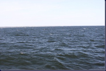
See how wide the Potomoc River is?
IMG_4207

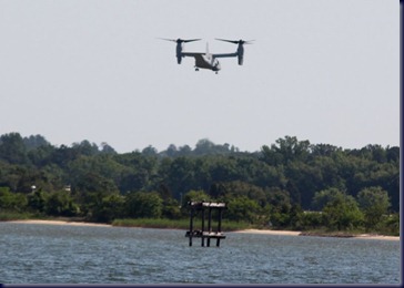
There’s a naval base nearby on the Bay, so while underway we saw an Osprey maneuver around for over an hour, sometimes in airplane mode, other times in helicopter mode.
IMG_4218

We crossed the border into Maryland today, and the shoreline looks different here, mostly because there is actually some elevation. Florida, Georgia, the Carolinas and Virginia are mostly flat along the coast (ever heard of “low country”? That’s what they are).  Maryland has hills and low cliffs along the shoreline.  St. Mary’s River is sparsely populated and houses are on huge lots.

IMG_4223

IMG_4225

We reached our anchorage at St. Mary’s College of Maryland, a small (2,000 students) liberal arts “honors” college that specializes in teaching students to be excellent sailors in addition to their academic lessons. They have many Flying Juniors (smaller versions of the Flying Dutchman) and teach racing skills.

IMG_4230

We were allowed to tie up at their dock for the afternoon so we could wander the campus and have lunch in the Student Center. Graduation was a week ago, so there weren’t many students around. It’s a very pretty campus.

IMG_4253

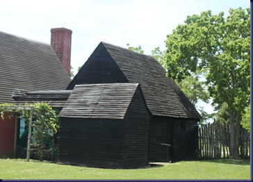
There’s also the old town of St. Mary’s City across the road, which was the first capital of Maryland and was established as an English settlement 380 years ago. They’ve reconstructed many of the original buildings, have archaeological digs ongoing, and offer lots of history. This is a reproduction of the original Sate House.

IMG_4236


IMG_4247


IMG_4237

The College sits on Horseshoe Bay, an almost perfect oval that is a mile long and half a mile wide.

IMG_4251

While we were tied up at the dock, a dozen students enjoyed sunning themselves and swimming. One young woman (see below) reminded us of our youngest daughter Adrienne, who was a diver on her high school swim team, when she did a back flip off one of the pilings into the water.

IMG_4256

After we finished touring the campus and old city, we moved the boat off the dock and anchored nearby for the night. The wind has settled down, and we’re strategizing our day tomorrow as we hope to travel north again. The weather forecast is much the same for the next week, so we can’t out-wait this “snotty” weather!

Thursday, May 17, 2012

Tangier Island, VA

Days on cruise:  55

IMG_4136

This morning we pulled up the anchor and moved about a mile to Buzzard’s Point Marina, the jumping-off spot for a ferry ride to Tangier Island in the middle of Chesapeake Bay. Even in that short distance, there were lots of menhaden boats coming and going.

IMG_4156

This sailboat was anchored next to us last night, it left early this morning, and we saw it coming back in again when we were on the ferry, perhaps because the wind and waves were so high, with swells too, that it would not be a fun day to be on a smaller boat on the Chesapeake.

IMG_4157

At 9:30 we boarded the “Chesapeake Breeze”, a commercial ferry which carries up to 150 people, though there weren’t more than 75 today. It was a somewhat rough ride for 18 miles, and some people on the ferry got seasick, an affliction  we fortunately avoided, having long since acquired our sea legs. An hour and 40 minutes later, we entered the harbor at Tangier Island.

IMG_4160

This place is pretty unique and interesting. It’s 3 miles long by 1.5 miles wide, 18 miles from either the eastern or western shore of the Chesapeake, and has a population of year-round residents just under 500, down from 2,100 at its’ peak. The highest point on the island is only 4 feet above sea level, and the entire population is evacuated every time a hurricane threatens the area. Almost all of the residents work in the crabbing or oyster industry.

IMG_4166

The crab industry here is primarily “soft-shelled crabs”, the kind that molt to allow for growth. The crabs are captured just before molting begins, then put in plastic basins that are fed with bay water and must be checked every two hours around the clock, demanding work.  Tangier Island is considered the Soft Shell Crab capital of the nation.

IMG_4168

Resident crabbers have “fish shacks” on the waterway with small docks attached where their boats are kept. There are a couple hundred of these just inside the harbor.

IMG_4187

There are only a handful of motorized vehicles on the entire island, and most people get around by walking, bicycling or most commonly, riding golf carts. There are mobile homes, small cottages, modest homes in good repair, modest homes in bad repair, and well-kept Victorian style homes on the island.

  • 2012-05-17

Dozens of homes have signposts in front of them telling the history of the home.  We found the one below particularly interesting and amusing.

IMG_4188

Island residents speak an English restoration-era dialect of English that is similar to that spoken in England in the late 1600s, and linguists like to come here to study it. We’re told it’s sometimes difficult for people to understand, though the few residents we spoke with were not hard to understand.

IMG_4199

There’s one school on the island, and the classroom for each grade has fewer than 10 students. Medical service is provided by three Physicians Assistants and Registered Nurses, with a doctor who arrives once each week by helicopter. Cable TV and Internet came to Tangier Island in 2010.

We took a 20-minute tour of the island with a local resident on her golf cart (cost $5.00 each), ate lunch at a local cafe (soft shell crab sandwich for Cathryn, crabcake sandwich for Bob) and walked the narrow streets until it was time to return to the ferry for our ride back to Buzzard’s Point Marina, where we’re allowed to stay on the dock for the night for free because we took the ferry ride.

This was a fascinating cultural/sociological journey and reminds us yet again that America is an amazingly diverse place, and we’re happy to be seeing so much of it on our Great Loop trip.

Wednesday, May 16, 2012

Reedville, Virginia

Days on cruise:  54
Today’s travel:  27.3 miles
Time traveled: 3 hours 16 minutes
Total trip odometer: 1,184 statute miles
We got away from Deltaville Boatyard early this morning and found the Chesapeake Bay essentially calm with flat water for most of the way. There are points of land with big shallow shoals much of the way, so we were 3-4 miles offshore with few navigation aids and few other boats.
The photo below is of the navigation light at the entrance to the Great Wicomico River.  There used to be a real lighthouse here, but it was crumbling and was therefore removed during the 1960s.
IMG_4123
Once we got onto the river, we began to see lots of  watermen, the term they use for folks who work the fishing industry.  This is a crab fisherman with piles of crab pots on the back of his boat.
IMG_4119
After traveling up the Wicomico River, we turned into Cockerell Creek which leads to the town of Reedville, VA, population 2,133. The stack in the photo below is from an old, now abandoned, fish processing plant.
IMG_4128
There are lots of Menhaden fishing boats in the area. More on that topic later. The pretty blue one below is an example.
IMG_4130
Cathryn almost never starts or drives the dinghy when we are anchored somewhere and go ashore. She last did it in the Florida Keys, so decided it was time to do it again so she wouldn’t forget how. After we anchored, we dropped the dinghy in the water to explore Reedville.
P1000609
See our boat in the background ?  We went ashore to the Cockerell Creek Seafood and Deli, which is adjacent to a fish processing place.  We ordered lunch (oysters for Cathryn; crabcake sandwich for Bob) and ate outside on the shore, looking at our boat and anchorage.  Pretty! Tonight there are two sailboats anchored near us.
P1000611
There’s no real downtown in Reedville. Instead there’s Main Street, lined by mostly well-cared-for Victorian homes built in the  late 1800s and early 1900s, and an occasional shop or cafĂ©.  The houses are mostly on large lots, and almost all are waterfront, as Main Street runs along a narrow spit.
IMG_4140
We spent an hour in the Reedville Watermen’s Museum which was astonishingly well-done in any case, but especially considering it’s in such a tiny town. Among other things, the Museum tells the story of the Menhaden fishing industry.  All you east coast folks may laugh at us ignorant west coast folks, but we don’t know anything about Menhaden. If any of you say you’ve ever eaten Menhaden, we know you don’t know anything about it either. They’re not edible. At least not as fish. But if you’ve ever worn cosmetics, eaten baked goods with margarine or shortening in them,  or painted anything with Rustoleum paint, you’ve probably used a product that includes Menhaden.
Believe it or not, Reedville, VA has the second largest haul of fish processed in the U.S. each year, lagging only behind Dutch Harbor, Alaska!
The Watermen’s Museum also has a small-boat building and restoration yard, and we enjoyed the products of their labor.
IMG_4143
IMG_4146
This is a nice little town worthy of a days’ stop.

Tuesday, May 15, 2012

A Day in the Boatyard

Days on Cruise:  53

2012-05-15

We enjoyed our first night living on the hard. Jim and Mimi from Canada, also on the hard in their boat nearby, proposed we share dinner in the screened porch barbecue area. The four of us are the only people living on our boats here, so it’s pretty quiet after 6:00.  Cathryn put together appetizers  and contributed spinach for the salad and edamame for a side dish. Mimi made  marinated, barbecued chicken wings, and tossed together the salad ingredients. It was BYOB of course. We each brought our own plates and flatware, lit the candles, and spent 3 hours cooking, telling stories and sharing a fabulous meal. What a great evening!

images

2012-05-151

Max, Dan, Matt, John, Ashley, Amanda, Cheryl, Ed, Ken: we know most of the folks who work at the Delatville Boatyard now. They’re all friendly, competent professionals, each of whom spent a part of their workday with us. We got all new zincs, the new cutlass bearing was installed, and the sea strainers were cleaned. Bob worked on cleaning and polishing the exterior of our boat; Cathryn finished scraping off the small barnacles on the bottom that weren’t removed by pressure-washing and took care of some of our personal business.  And finally at 3:30 John loaded us back up on the Travel Lift and splashed us back into the water. Max went into the engine room to adjust the shaft logs, and off we went -- a whole 500 feet to spend tonight on their fuel dock!

P1000605

We had picked several alternative anchorages for tonight depending on what time we got away from the boatyard, but by 3:30 the wind had come up too high and it was too late in the day to make it to even the closest anchorage.  Oh well, we’re happy we made the stop and got some things taken care of, and tomorrow we’ll have a whole day to move onto more interesting activities.