Tuesday, April 24, 2012

Still Waiting in Morehead City, NC

We arrived here Saturday to wait out some bad weather, and if all goes as planned, we will finally leave here to head for Oriental, NC or further north on the Neuse River very early tomorrow morning, Wednesday. The early morning hours are usually somewhat calm, as are the early evening hours, but it blow hard all day between times.  So we’ll leave early, make as much progress northward as possible until the wind comes up, then anchor out and try Jim A and Boatman Mark’s revised anchoring techniques to see if that solves our problems.

The folks here at Portside Marina have been great! Denard, Kay and Kara have been friendly, welcoming and helpful, and their marina has been a wonderful place to wait out the storm.  Their rate is $1.50/foot, including electricity, and if you stay more than one night, it’s $10.00 off each night. And they have free laundry!  What more could you ask for? 

Well, we asked for more: some help finding someone to do an oil change for us, and Denard arranged to have Andrew from A-1 Marine and Diesel Service show up on our boat bright and early Monday morning, do the oil change, and replace a leaking water pump on the starboard engine. Andrew was just great, and took care of us quickly and expertly. He also noticed our transmission gear shift cables needed adjustment and threw in a bit of extra time to take care of that before we leave.

And last but not least, it’s only two miles to downtown Beaufort from here, and Portside Marina has bicycles you can use to go to town. We highly recommend a stop at Portside Marina with their floating docks and clean restrooms if you plan to stop in the Beaufort area.

Sunday, April 22, 2012

Waiting on the Weather

Last night the weather came up as forecast. It was blowing steadily 20-25 mph at our last check before going to bed. Because we’re on an outside face dock, with the wind coming from the south directly at our beam, it made for a  bouncy night til things settled down about 2am. Cathryn actually lay in bed chuckling occasionally at first, as she felt  she was about to be thrown out of bed onto the floor. 

rain

Today it’s raining, visibility is greatly reduced, and the wind blows up for several hours, dies back, then blows up again. We’re glad we’re not out there traveling in it.

weather

Loopers are some of the nicest folks, and we have a recent example of friendship that is “above and beyond”.  In March on our shake-down cruise to the Florida Keys, we met Jim  and Sharon A in the mooring field at Marathon. They’ve lived full-time on their boat many years now (13 or 14?) and have completed the Loop twice. We met them at a Looper gathering, then had cocktail hour on their boat the night before we left the Keys.  Since then, Jim and Sharon have followed our blog, and Jim and Cathryn have emailed back and forth about various boating topics.

IMG_3793

Three days ago Cathryn received emails from both Boatman Mark and Jim A who had read of the troubles we were having with anchoring. Both asked what type and size of anchor we were using and offered some helpful thoughts.  Since we saw them, Jim A and Sharon have taken their boat out of the water in Alabama (headed upriver to relatives in Michigan) to get some work done, and they got a phone call saying Jim’s Dad was suddenly ill and not expected to live long.  Jim and Sharon jumped in a car and drove to Michigan in two days. Despite this, Cathryn got a phone call from Jim yesterday wanting to review our anchoring procedure with us, as he had a new idea about what might be causing our problems. They talked for 20 minutes and we THINK he’s on to something!  Cathryn reviewed the steps we follow in anchoring, and Jim thought it all sounded right until we got to the point of “setting” the anchor. He thinks because our boat is over-powered for our needs (two 385 hp Caterpillar 3126 engines, more than needed to travel at trawler speed of 8 mph), that we’re probably yanking way too hard on the chain to set it, plowing our anchor through the mud/sand rather than actually setting it.

IMG_3794

He suggested in the future we try using only one engine to back down on the anchor, and do it only at idle speed without revving up the engines in reverse, and see if it works better. His Lehman 135 hp single engine does a good job of setting the anchor at idle speed, so it certainly sounds plausible to us that this is our problem.  Now if the weather would just improve so we could get going again, we’re eager to give his suggestion a try!

Saturday, April 21, 2012

Plan B

Last week we posted that we were running a bit ahead of schedule and considering taking a side-trip off the ICW/Loop route for a week or so.  We got suggestions from several people and began formulating a plan to go to the Outer Banks on the far side of Pamlico Sound. We inquired of folks at the marina to gather local knowledge about the best route, got  a boating map with routes laid out, posted on the Great Loop website and got some suggestions from folks . . .  and then we checked the weather forecast!

photo (8)

A cold front is to arrive tonight and bring with it rain, cooler temps, and most importantly, WIND! For the next week, the forecast calls for steady wind in the 18-25 mph range, with gusts in the 25-49 mph range.  While adventurous sailors may like that sort of weather, trawlers and their captains don’t.  We’re comfortable traveling within the protected stretches of the ICW with wind and gusts up to about 20 mph. Everyone we’ve talked to says trawlers have no business on the Pamlico Sound in winds greater than 15 mph. Pamlico Sound is 80 miles long and 15-30 miles wide, and is the largest lagoon on the Eastern U.S. coast, much bigger than our home cruising grounds on Puget Sound. Unlike Puget Sound, where waters are typically 100 – 400 feet deep, Pamlico Sound is mostly 20-25 feet deep, though shallower in some places. So it has no ocean swell, being separated from the Atlantic by the very low islands of the Outer Banks, but because of the long fetch and shallow water, we’re told it has very bad waves and chop.

pemlico sound

Our other option, to continue northward now on the ICW/Loop route is also inadvisable because of this weather.  We’d have to travel the very large Neuse River and cross Albemarle Sound, both of which will have conditions beyond what we would do in our trawler. The one rule we have always heard about the Loop is: don’t have a schedule! Weather and other unplanned events, which will not be named, will happen to foul it up.

photo (7)

So . . . what to do, what to do? We were paying a premium marina price during our wonderful two days in Beaufort and didn’t want to continue for up to another week. So this morning we back-tracked 5 miles to Morehead City, NC to Portside Marina where the nightly price is half what it was in Beaufort, and the laundry room is free.

Morehead City is a real “Fisherman’s Town”, with much less tourism and more of a blue collar feel than Beaufort. A huge percentage of its’ residents are employed in one manner or another in the boating industry, and most of it in fishing.

So again, we’re considering alternatives. We decided not to fly to Houston, Denver or Seattle to visit relatives for various reasons, so we’re working on local options to keep us happy and occupied for up to a week while we await a turn in the weather. At a minimum we will catch up on our reading, which has been much neglected on this trip so far.

Friday, April 20, 2012

History, Wooden Boats and Pirates

Beaufort, NC is a pretty town. Its’ downtown core is small, attractive, and loaded with old homes on the National Historic Register.  At the Visitor’s Center we obtained a map showing us the self-guided walking tour and enjoyed the information included about each house.

IMG_3742

These are more modest homes than those in Charleston, but are uniformly in good condition and attractive. Swings and rocking chairs on the front porches are almost ubiquitous.

IMG_3746

As in Charleston and other cities we’ve visited, boxwood hedges are popular. The one below is interesting in that it is fashioned as a maze or labyrinth.

IMG_3737

We spent time at The Old Burying Ground, where many former residents of Beaufort from the Revolutionary and Civil War days are buried, in addition to non-military citizens. It’s a pretty cemetery, and information from the Visitor’s Center gave us the “life stories” of some of the folks buried here.

IMG_3741

We spent an hour at the excellent Maritime Museum which had lots of interesting exhibits, including the one below which is of a device used to shuttle up to 15 people at a time from shipwrecks offshore back to Beaufort on ropes shot via cannon to the shipwreck! It looked frighteningly claustrophobic, but we’d guess that once you’re shipwrecked, your options feel limited, so you’d climb into this thing with 14 of your closest friends if given the choice!

IMG_3751

We also spent a brief time at the wooden boat center, though no one was working there at the time. There were some beautiful examples of work underway.

IMG_3755


IMG_3760

And a few final products tied up at the docks outside. Pretty!

IMG_3761

Tonight at the restaurant/bar immediately adjacent to our dock they’re having a Fundraising Event. If we understood it correctly, there is a “pirate’s organization” here in Beaufort, and the funds raised are to help the continuance of this organization. There’s even a guy named Sinbad (not his real name we’d guess?) who built his 54-foot brigantine pirate’s ship Meka II in Detroit in 1967 and lives on her full-time here in Beaufort. He stages historical re-enactments of pirating events and invites students on board to learn pirating history. He is actually a licensed (by the state of North Carolina) privateer. His boat is docked a few feet from ours tonight.

IMG_3766

Beaufort residents are out in large numbers in pirate and wench costume for tonight’s event.

IMG_3734


IMG_3750


IMG_3780

Here we are below, in our dockage in Beaufort, NC.

IMG_3763

Camp LeJeune, NC to Beaufort, NC

Days on Cruise:  27

Miles Today: 42.2

Travel Time Today:  5 hours, 6 mins

Total Odometer:  833 statute miles

IMG_3714

It was a shorter journey today than usual.  We were the first boat to arrive at yesterday’s anchorage in Camp LeJeune (Mile Hammock Bay), and by the time we went to bed there were 3 sailboats and 2 other trawlers anchored there.  We were the last to leave this morning at 8:00. Four miles into today’s trip we encountered a bridge with only 12-foot clearance (we need 19 feet), so had to time our every-30-minutes-bridge-opening, and we figure with that, plus the shallow waters through 25 miles of Bogue Sound (at high tide early, but low tide later) meant that all the sailboats needed to get an early start with their deeper drafts. One trawler larger than ours admitted on the VHF radio that they had trouble yesterday finding the center of the channel and touched bottom at one point, so they followed us for the first 30 miles today, perhaps figuring if we didn’t have any trouble, they wouldn’t either. And we didn’t.

images

Bogue Sound was another one of those strange (to our West Coast eyes) places where we were in the very wide ICW channel all day with depths of 6 – 18 feet beneath our hull, but JUST outside the channel, it’s charted at 1-2 feet deep at Mean Low Tide.  The photo above depicts how unlikely this seems! We’ve seen several “fishing shacks” like the one below.

IMG_3727-001

We settled in at Beaufort Docks marina for two nights so we can experience another historical, lively city.  For the first time, we used a “courtesy car”, one of the benefits offered by some marinas: a free loaner car usually available for an hour or so to make a run for groceries, West Marine or the hardware store.  Take a look at this rig!  The photo makes it look good, but this car has seen a long life already!

P1000468

When we returned the car, we told the guy they should hand out Dramamine along with the keys, as it took us for quite a ride! But we were very, very appreciative for its use.

IMG_3729

We ate dinner in town at Clawson's 1905 and couldn’t believe the check: $27.52 for two dinners and three beers!  Can’t get that in Olalla, WA where we live.  And it was even tasty food with decent beer. 

Too bad the rest of the city is not similarly value-priced.  The City Marina is $2.30 a foot, plus electric, and most of  the resturants here seem quite pricey for cruisers, mid $20-$40 per entrée.

Thursday, April 19, 2012

Morning After

No, it’s not one of those stories.  Sorry.

 IMG_3714

Yesterday afternoon we wrote about all the helicopters and planes flying overhead, with artillery sounds in the distance.  Just after dark we found out what “busy” is.  There must have been half a dozen helic0pters flying low and fast over the bay where we were anchored, seemingly only a few hundred feet above us, though hard to tell in the dark. Occasionaly lights were blinking, and they were occasionally doing touch and goes in the nearby woods.  We grabbed a glass of wine and went out on the foredeck to sit and watch the show. Though the show went on for hours, we finally went back inside and off to bed.

IMG_3715

Obviously they were doing exercises, and we could only imagine what it must be like to be an Afghan village tribesman living in remote areas and experiencing the real thing, these same sounds, though of course we didn’t feel threatened. Though Cathryn did (jokingly) wonder aloud how quickly we could get up to the flybridge if the boat sank because something landed on us and sank us. Drama queen!And if that were to happen, there wouldn’t be a flybridge to get up to, would there?

IMG_3718

This morning we’re traveling through a 10-mile stretch of the ICW that actually is within Camp LeJeune. They occasionally close the waterway for hours to practice their gunnery.  Luckily, today no shots were fired.

IMG_3720

There are lots of “targets” on the nearby shore.

It’s very foggy this morning, so we’re traveling a little more slowly, have the radar on, and both staying on the flybridge all the time to keep an eye out for approaching boats and day markers. It’s harder to spot everything in these conditions.

Wednesday, April 18, 2012

Flying Through North Carolina

Days on Cruise: 26

Miles Traveled Today:  52.6

Hours Underway:  6hrs 41 minutes

Total Odometer:  791 statute miles

P1000466

OK, maybe at 50 to 60 miles a day, “flying” overstates our speed. For those who think of traveling at highway speeds, having spent 4 days in one state and still being 200 miles south of the border doesn’t seem fast.  But for those who think in “trawler speed”, we’re moving right along. Our mission tonight, as part of our normal after dinner “charting time” is to figure out how to slow it down, perhaps by taking a side trip off the actual Loop sometime in the next few weeks. Ideas anyone? Outer Banks? Potomac River?

IMG_3709

North Carolina redeemed itself in our minds today.  Yesterday we thought the scenery was not very interesting, but today made up for it:  gorgeous!  For much of the ICW in Florida, George and South Carolina, we rarely or never saw the ocean, being further inland. Today we saw the Atlantic Ocean repeatedly, either at inlets from ocean to ICW, or else by looking over the marshes and sand dunes, where we could see the ocean just beyond.

IMG_3680

As we’ve said before, we aren’t big restaurant aficionados, and if there is not something specific we need right now, we do NOT like to shop.  So as we move up the ICW, we see lots of beautiful scenery but have not yet found a town that causes us to want to stop and tarry.

IMG_3681

We’ve seen lots of folk who erect inventive signs to slow boaters down (to reduce their wake, limiting damage to the shoreline or boats moored along the shoreline), but it’s not clear they really work for the boaters that just don’t care. We passed one marina yesterday at the same time a fast boat passed.  The folks at the marina started out politely asking them via VHF radio to slow down, then over about 4 steps, escalated to shouting.  At the end, the folks at the marina plaintively asked. “Can’t you hear us”? The answer: “Loud and clear”, but they didn’t slow down.

IMG_3695

We have at least two places that may slow us down before we leave North Carolina:  Beaufort, NC (pronounced Bo-furt), not to be confused with Beaufort, SC (pronounced Byoo-fert)) and the Dismal Swamp. If any readers have any local knowledge of “must-sees” that don’t include restaurants or shopping, let us know.

2012-04-18 

Interesting yard art today.  We think the huge giraffe is a real estate gimmick: the sign next to it says “for sale”.

2012-04-181

We’re spending tonight anchored in Mile Hammock Bay at the southern edge of Marine Base Camp LeJeune.   After two nights in which we were unable to get our anchor to set, we succeeded tonight. Yea! Camp LeJeune is a Marine training facility, training 40,000 Marines each year!  Interesting place: we hear artillery fire in the distance fairly constantly, see lots of Osprey (a vertical lift aircraft) and a variety of helicopters. Hope they’ll take the night off!

We’ve read that 10 miles of the ICW (tomorrow’s territory for us) travels through Camp LeJeune, and at times they close the ICW for an hour or two, occasionally for a whole day, because of firing practice that makes ICW travel unsafe. We’ll be listening on the appropriate radio channel tomorrow morning before we leave to learn whether tomorrow’s travel will be impacted.

Tuesday, April 17, 2012

State #4

Days on cruise:  25

Miles today: 54.3

Travel Time:  6 hrs 29 mins

Total Odometer:  738 miles

IMG_3667

Coming from the west coast of the U.S., we’re accustomed to traveling from Canada to Mexico and only going through 3 states. Here on the east coast, the state lines arrive so quickly we’re taken aback!  We can’t believe that even at 50 miles a day, when we’ve traveled less than a month since the beginning of our Loop, we’ve now crossed into North Carolina, our fourth state.

IMG_3663

Our day was uneventful. We spent much of the day in man-made cuts, plenty deep, but narrow and with few trees or birds or other things of interest.  There were several ocean inlets, and they brought us literally to the edge of the Atlantic, all heavily shoaled with sandy beaches, but this segment of the ICW was just dredged in February, so we had no problems crossing the inlets.

IMG_3675

Toward the end of the day we entered the Cape Fear River, a huge, wide river with both swells and chop, plenty of wind, and both the swells/waves and wind were coming from the stern port quarter which made travel a little uncomfortable, as the boat swung through 30-degree adjustments on auto pilot and was even worse without auto pilot.  We tried speeding up to get through it quickly, but that only made it worse as we briefly lost steerage each time we came down the face of a wave, so we slowed back to our normal trawler speed (8 knots).

P1000458

We arrived at our intended anchorage, Carolina Beach, and yet again, failed twice to set the anchor, so we left to spend the night in a State Park marina, large, mostly empty, and cheap:  $30 including water and electricity.

IMG_3673

We had an email message from a friend telling us he thought our anchoring problem was the type of anchor we have, which is the one that came with the boat.  So, we’re beginning research on whether a different type of anchor, either the back-up we already own, or another type, might yield more reliably good results.  Opinions on what is the best anchor are endless and without objective answers, so the “no action” alternative is alive and well (in addition to being the cheapest).

P1000454

Once tied up at our dock, we took a short hike through the park, which is noteworthy primarily because it’s the home of indigenous Venus Fly Traps!  It’s early, so they’re not yet in “bloom”.

P1000455

Monday, April 16, 2012

Waccamaw River, The Rock Pile And The Anchor Would Not Set!

Butler Island Anchorage, SC to Lightkeeper’s Marina, Coquina Harbor, North Myrtle Beach, SC

Days On Cruise: 24

Today’s Distance:  60.9 miles

Total Odometer:  684 miles
IMG_3619W

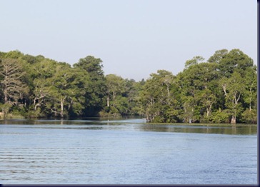
Our Saturday night anchorage spot behind Butler Island on the Waccamaw River was so quiet, secure and beautiful that when we got up Sunday morning we decided to do something we’ve not done before:  take a day off! Instead of motoring further northward, we spent the day in our anchorage puttering on minor boat projects, reading books, taking a nap and generally relaxing. This was the first day we’ve had a “down” day with no driving our sightseeing, and it was great!  We intended to drop the dinghy and explore the creek adjacent to our anchorage, but the wind stayed pretty high all day, so we never got around to it. There was only one other boat in sight, a sailboat anchored about a mile south of us.

Click on the photo below and what do you see in the giant nest at the top of the snag tree?

IMG_3626

Monday morning we spent 30 miles (about  3 1/2 hours) traveling through Cypress swamp land, which includes lots of trees growing in the water. It’s all part of a huge National Wildlife Refuge and as far as we’re concerned, is the most beautiful stretch of the ICW we’ve seen yet.  We’d heard other people say this would be the case, that it was their favorite stretch, but we were still caught by surprise at the 8 shades of vibrant green, quiet, lack of ANY development, and remoteness. Lots of birds, no manatees or even dolphins!

IMG_3632

The photo below shows what “billboards” look like along the waterway. There aren’t many, but this particular marina had a billboard up about every 5 miles.

IMG_3625

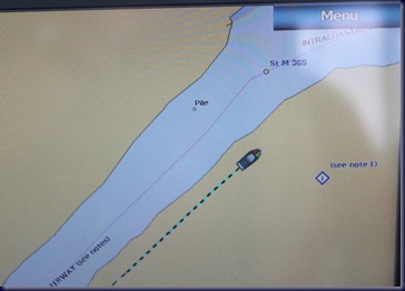
When we were younger adults, we were interested in hiking and mountain climbing, so took a rigorous mountain-climbing class. During ensuing years of hiking and climbing, we came to understand that a GPS was ALWAYS to be trusted more than our own eyes:  it would tell us when we were on a false summit and needed to climb up the next ridge to the true summit, and it would tell us when we were approaching cliffs we might fall off of, even if we couldn’t see them.  The ICW has turned this piece of training completely upside down! During our 3 days of training with Captain Chris Caldwell in January, he told us repeatedly, “Anytime there is a conflict between what your GPS/chartplotter is telling you, and what your eyes are telling you, don’t believe the GPS; believe your eyes!”   We’ve had many examples that have proven the truth of this statement, and finally caught a photo of one today that illustrates the point. Do you really believe we were driving our boat this far up on land today?????
IMG_3635-001

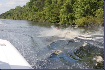
You can’t actually see the cause of the disturbance on the water in the photo below, but it was two jet-skis that came zipping toward us on the river, then turned sharply to jump our wake; looked like they thought it was great fun!
IMG_3636-001

After the 30 miles of spectacular beauty on the Waccamaw River, we entered a man-made canal called the Pine Island Cut. Mile after mile, it was land that had been scraped clear of all growth by development, and big houses put up in new developments. The weird thing was there were no trees in the new developments, and most of the lots were empty, so the scrunched together houses that were there looked strange. We thought it an unattractive stretch.

IMG_3638

And finally we came to the Rock Pile, of which we’d been warned only a few days ago. We were told the channel here was very narrow, plenty deep, but lined by rocks that were invisible at high tide, but could be seen at low tide, so it was important we stayed in the middle of the channel, as hitting the Rock Pile would not be forgiving like the sand in the rest of the ICW we’ve traveled so far.  Our journey through this stretch was thankfully uneventful.

IMG_3655

The color in this photo is not “true”. In fact, the entire house, trim, dock, ramp, everything was one shade or another of PURPLE!  Interesting?

IMG_3657

We arrived at the Calabash Creek anchorage about 3:00 and had a new experience: we were unable to set our anchor! The wind was blowing pretty hard, the current was fast as there’s an ocean inlet nearby, and the water was shallow with crab pots every couple hundred of feet. We made two attempts at anchoring, and neither was successful. We knew the 6 feet of water would drop 2-3 more feet during the night, and the narrow channel meant we might end up on the shore in only two feet of water with the tide swing.  So, we called it good and headed to the closest marina, where we’re spending the night for only $1.00/foot, the cheapest marina we’ve stayed in to date.

IMG_3659

This is a big, full marina, but as far as we can tell, we’re the only people staying on our boat tonight. There are no other people around!  That’s fine by us.  We filled our water tanks, declined the option of hooking up to electricity, had a good dinner and called it a night.